


La Clusaz les confins chalet de Pacaly

marcagif
User
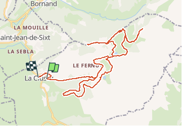

Length
28 km

Max alt
1608 m

Uphill gradient
1024 m
Km-Effort
42 km

Min alt
1040 m

Downhill gradient
1108 m
Boucle
No
Creation date :
2020-07-12 12:34:37.463
Updated on :
2020-07-12 16:28:05.132
3h02
Difficulty : Easy

FREE GPS app for hiking
 SityTrail
IGN / Geographical institutes
SityTrail Plus
The world is yours!
About
Trail Mountain bike of 28 km to be discovered at Auvergne-Rhône-Alpes, Upper Savoy, La Clusaz. This trail is proposed by marcagif.
Description
depart skisset la clusaz
Positioning
Country:
France
Region :
Auvergne-Rhône-Alpes
Department/Province :
Upper Savoy
Municipality :
La Clusaz
Location:
Unknown
Start:(Dec)
Start:(UTM)
300616 ; 5086588 (32T) N.
Comments